Stacking ensemble machine learning for predicting land surface temperature hotspots using landsat 9 data

Authors

  • Momohjimoh Abdulsalami Department of Physics, Confluence University of Science and Technology, Osara
  • Dahiru Dahuwa Department of Physics, Federal university of Health sciences, Azare
  • Saratu Muhammad Hussaini Department of Physics, Air Force Institute of Technology, Kaduna
  • Yahaya Jibrin Danjuma Department of Mathematics and Statistics, Confluence University of Science and Technology, Osara
  • Michael Adewale Ibitomi Department of Mineral and Petroleum Resources Engineering, Kogi State Polytechnic, Lokoja
  • Danga Onimisi Abdulmalik Department of Geosciences, Confluence University of Science and Technology, Osara
  • Bunmi Oyekola Isaac Department of Geosciences, Confluence University of Science and Technology, Osara
  • Zainab Usman Department of Geosciences, Confluence University of Science and Technology, Osara
  • Joseph Omeiza Alao Department of Physics, Air Force Institute of Technology, Kaduna
  • Aliyu Abdullateef Department of Geosciences, Confluence University of Science and Technology, Osara

Keywords:

LST, Geothermal energy, Machine learning, Landsat 9

Abstract

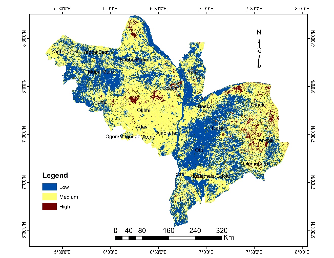
Despite advancements in predictive modeling, existing methods struggle with accuracy and spatial variability in Land Surface Temperature (LST) estimation. This study presents a Stacking Ensemble Model (SEM) integrating Random Forest (RF), eXtreme Gradient Boosting (XGBoost), and k-Nearest Neighbors (KNN) to enhance LST prediction using Landsat 9 and SRTM DEM data in Kogi State, Nigeria. The SEM outperformed individual models, achieving an R² of 99.86%, surpassing RF by 3.31%, XGBoost by 8.03%, and KNN by 12.79%. Results revealed significant spatial variability, with temperatures ranging from 24.8°C to 49.3°C and critical hotspots above 40°C covering 1,035 km², supporting geothermal energy exploration. Incorporating elevation spectral indices and key predictors like NDVI, proportion of vegetation, land surface emissivity, and brightness temperature further improved accuracy. This SEM framework enhances predictive robustness, scalability, and spatial analysis for better LST modeling.

Dimensions

[1] M. G. Ayuba & M. K. Lawal, ‘‘Investigating geothermal energy resource potential in parts of southwestern Nigeria using aeromagnetic data’’, Science World Journal 14 (2019) 1. http://www.scienceworldjournal.org.

[2] T. Suleiman, F. N. Okeke & N. D. Obiora, ‘‘Spectral analysis of high-resolution aeromagnetic data for geothermal energy reconnaissance across Sokoto Basin, Northwest, Nigeria’’, Journal of the Earth and Space Physics 46 (2020) 147. https://doi.org/10.22059/jesphys.2020.299866.1007205.

[3] X. Zhang, Q. Zhang, G. Zhang, Z. Nie, Z. Gui & H. Que, ‘‘A novel hybrid data-driven model for daily land surface temperature forecasting using long short-term memory neural network based on ensemble empirical mode decomposition’’, International Journal of Environmental Research and Public Health 15 (2018) 1032. https://doi.org/10.3390/ijerph15051032.

[4] S. L. Ermida, P. Soares, V. Mantas, F. M. Göttsche & I. F. Trigo, ‘‘Google earth engine open-source code for land surface temperature estimation from the landsat series’’, Remote sensing (Basel) 12 (2020) 1471. https://doi.org/10.3390/RS12091471.

[5] J. Alzubi, A. Nayyar & A. Kumar, ‘‘Machine learning from theory to algorithms: an overview’’, Journal of Physics: Conference Series 1142 (2018) 012012 https://doi.org/10.1088/1742-6596/1142/1/012012.

[6] M. O. Ibitoye, O. G. Aderibigbe, S. A. Adegboyega & A. O. Adebola, ‘‘Spatio-temporal analysis of land surface temperature variations in the rapidly developing Akure and its environs, southwestern Nigeria using Landsat data’’, Ethiopian Journal of Environmental Studies and Management 10 (2017) 389. https://doi.org/10.4314/ejesm.v10i3.9.

[7] D. Dissanayake, T. Morimoto, Y. Murayama, M. Ranagalage & H. H. Handayani, ‘‘Impact of urban surface characteristics and socio-economic variables on the spatial variation of land surface temperature in Lagos City, Nigeria’’, Sustainability 11 (2019) 25. https://doi.org/10.3390/su11010025.

[8] P. Nwilo, D. Olayinka, J. Obiefuna, A. Atagbaza & A. Adzandeh, ‘‘Determination of land surface temperature (lst) and potential urban heat island effect in parts of Lagos state using satellite imageries’’, FUTY Journal of the Environment 7 (2012) 1. https://doi.org/10.4314/fje.v7i1.2.

[9] X. Wang, L. Zhong & Y. Ma, ‘‘Estimation of 30 m land surface temperatures over the entire Tibetan Plateau based on Landsat-7 ETM+ data and machine learning methods’’, International Journal of Digital Earth 15 (2022) 1038. https://doi.org/10.1080/17538947.2022.2088873.

[10] M. ID, ‘‘Simulation and prediction of land surface temperature (lst) dynamics within Ikom city in Nigeria using artificial neural network (ANN)’’, Journal of Remote Sensing & GIS 5 (2015) 1. http://dx.doi.org/10.4172/2469-4134.1000158

[11] E. K. Mustafa, ‘‘Study for predicting land surface temperature (LST) using Landsat data: a comparison of four algorithms’’, Advances in Civil Engineering 2020 (2020) 7363546. https://doi.org/10.1155/2020/7363546.

[12] K. S. Kumar, K. P. Kumari & P. U. Bhaskar, ‘‘Artificial neural network model for prediction of land surface temperature from land use/cover images’’, International Journal of Advanced Trends in Computer Science and Engineering 2 (2013) 87. https://doi.org/10.1016/p.rdf.2013.02.003.

[13] M. Witjes, L. Parente & C. J. van Diemen, ‘‘A spatiotemporal ensemble machine learning framework for generating land use / land cover time-series maps for Europe (2000 – 2019) based on LUCAS, CORINE and GLAD Landsat’’, 2022. [Online]. https://doi.org/10.21203/rs.3.rs-561383/v4.

[14] X. Xu & Y. Wu, ‘‘Application of tree based enhanced stacking ensemble learning’’, 2023. [Online]. https://doi.org/10.21203/rs.3.rs-2471395/v1.

[15] E. J. M. Carranza, ‘‘Analysis and mapping of geochemical anomalies using logratio-transformed stream sediment data with censored values’’, Journal of Geochemical Exploration 110 (2011) 167. https://doi.org/10.1016/j.gexplo.2011.05.007.

[16] O. O. Ifatimehin, ‘‘An assessment of urban heat island of Lokoja town and surroundings using Landsat ETM data’’, FUTY Journal of the Environment 2 (2007) 1. http://dx.doi.org/10.4314/fje.v2i1.50790.

[17] P. Nwaerema, O. N. Vincent, C. Amadou & A. I. Morrison, ‘‘Spatial assessment of land surface temperature and emissivity in the tropical littoral city of Port Harcourt, Nigeria’’, International Journal of Environment and Climate Change 9 (2019) 88. https://doi.org/10.9734/ijecc/2019/v9i230099.

[18] J. Finger & D. Blankenship, ‘‘Sandia report handbook of best practices for geothermal drilling’’, 2010. [Online]. https://www1.eere.energy.gov/geothermal/pdfs/drillinghandbook.pdf.

[19] T. G. Farr et al., ‘‘The shuttle radar topography mission’’, Reviews of Geophysics 45 (2007) RG2004. https://doi.org/10.1029/2005RG000183.

[20] X. Ye, R. Liu, J. Hui & J. Zhu, ‘‘Land surface temperature estimation from landsat-9 thermal infrared data using ensemble learning method considering the physical radiance transfer process’’, Land 12 (2023) 1287. https://doi.org/10.3390/land12071287.

[21] USGS, ‘‘Landsat 8-9 Calibration and Validation Algorithm Description Document’’, 2021. [Online]. https://www.usgs.gov/media/files/landsat-8-9-calibration-validation-algorithm-description-document.

[22] L. Zhao, S. Lu & D. Qi, ‘‘Improvement of maximum air temperature forecasts using a stacking ensemble technique’’, Atmosphere 14 (2023) 600. https://doi.org/10.3390/atmos14030600.

[23] Astisiasari, D. R. Hizbaron & M. A. Setiawan, ‘‘Estimation of land surface temperature in dieng volcanic complex using TIR-based satellite imageries’’, IOP Conference Series: Earth and Environmental Science 451 (2020) 012066. https://doi.org/10.1088/1755-1315/451/1/012066.

[24] N. Zhang & K. Zhou, ‘‘Mineral prospectivity mapping with weights of evidence and fuzzy logic methods’’, Journal of Intelligent and Fuzzy Systems 29 (2015) 2639. https://doi.org/10.3233/IFS-151967.

[25] E. Boucher & F. Aires, ‘‘Improving remote sensing of extreme events with machine learning: land surface temperature retrievals from IASI observations’’, Environmental Research Letters 18 (2023) 024025. https://doi.org/10.1088/1748-9326/acb3e3.

[26] S. L. Ermida, P. Soares, V. Mantas, F. M. Göttsche & I. F. Trigo, ‘‘Google earth engine open-source code for land surface temperature estimation from the Landsat series’’, Remote Sensing 12 (2020) 1471. https://doi.org/10.3390/RS12091471.

[27] J. A. Sobrino, J. C. Jiménez-Muñoz & L. Paolini, ‘‘Land surface temperature retrieval from LANDSAT TM 5’’, Remote Sensing of Environment 90 (2004) 434. https://doi.org/10.1016/j.rse.2004.02.003.

[28] B. H. Tang, K. Shao, Z. L. Li, H. Wu & R. Tang, ‘‘An improved NDVI-based threshold method for estimating land surface emissivity using MODIS satellite data’’, International Journal of Remote Sensing 36 (2015) 4864. https://doi.org/10.1080/01431161.2015.1040132.

Published

2025-04-15

How to Cite

Stacking ensemble machine learning for predicting land surface temperature hotspots using landsat 9 data. (2025). Proceedings of the Nigerian Society of Physical Sciences, 2(1), 158. https://doi.org/10.61298/pnspsc.2025.2.158

How to Cite

Stacking ensemble machine learning for predicting land surface temperature hotspots using landsat 9 data. (2025). Proceedings of the Nigerian Society of Physical Sciences, 2(1), 158. https://doi.org/10.61298/pnspsc.2025.2.158