Investigating the connectivity of Geshere and Rishiwa younger granite using aero-radiometric data

Authors

  • Y. A. Bello Physics Department, Air Force Institute of Technology, Kaduna
  • K. M. Lawal Physics Department, National Open University of Nigeria, Abuja
  • S. S. Magaji Geology Department, Ahmadu Bello University, Zaria
  • J. Raimi Physics Department, Ahmadu Bello University, Zaria
  • T. O. Amuda Physics Department, Air Force Institute of Technology, Kaduna
  • D. Daramola Physics Department, Air Force Institute of Technology, Kaduna
  • M. B. Yakubu Physics Department, Ahmadu Bello University, Zaria
  • H. A. Lawal Physics Department, Air Force Institute of Technology, Kaduna

Keywords:

Geshere, Rishiwa, Radiometric data, Younger granite

Abstract

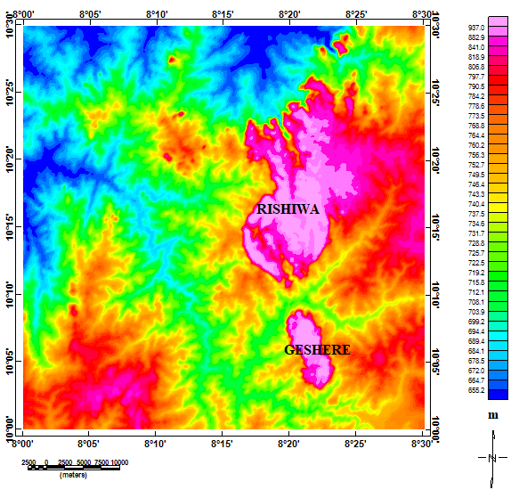
Geshere and Rishiwa Younger Granites (YGs) are physically two separate bodies and are believed to be either from the same source or one is an extension of the other. Previous work suggests they could be connected at the subsurface, but the use of radiometric data can provide clarity as it reflects rocks' geochemical formation. This work focused on identifying possible connection between the two YGs based on the variation of the radioelements in the study area. The result shows the values of potassium, thorium, and uranium range from 0.1 to 4.9 %, 11.9 to 61.2 ppm, and 1.4 to 10.3 ppm respectively, which are lower to the range of the radioelements (that of potassium is comparatively close) reported in part of Egypt. The average potassium concentration around Geshere and Rishiwa is high (4.5 and 4.1 % respectively), thorium is low (13.1 and 14.9 ppm respectively), and uranium is low around Geshere and south of Rishiwa YGs, but high at north of Rishiwa YG. The composite maps of the three radioelements and the potassium reveal the extent of the YGs. The Th/K map indicates the two YGs are connected. Moreover, the composite maps of thorium, and uranium suggested the south of Rishiwa and Geshere share similar geochemistry. Geochemical analysis is recommended on rock samples of a region west of the Gehere YG which is a Pan-Africa Basement Complex but shows anomalies similar to the YGs.

Dimensions

[1] S. I. Ibeneme, I. A. Oha , N. N. Abdulsalam & O. K. Mosto, “Improved mapping of the structural disposition of some younger granite ring complexes of Nigeria using high resolution aeromagnetic data,” Journal of Geology & Geophysics 7 (2018) 1. https://dx.doi.org/10.4172/2381-8719.1000443.

[2] P. Bowden & J.A. Kinnaird, “Geology and mineralization of the Nigerian anorogenic ring complexes: with a geological map at the scale of 1:500,000”, Geologisches Jahrb (Hannover) B 56 (1984) 3. https://www.schweizerbart.de/publication/detail/artno/186025600/Geology_and_mineralization_of_the_Nigerian_anorogenic_ring_complexes.

[3] D. E. Ajakaiye, “Gravity measurements over the nigeria younger granite province”, Nature 225 (1970) 50. https://www.nature.com/articles/225050b0.

[4] O. O. Osinowo, K. Alumona & A. I. Olayinka, “Analyses of high resolution aeromagnetic data for structural and porphyry mineral deposit mapping of the nigerian younger granite ring complexes, North-Central Nigeria”, Journal of African Earth Sciences 162 (2020) 103705. https://doi.org/10.1016/j.jafrearsci.2019.103705.

[5] C. O. Ofoegbu & K. Hein, “Analysis of magnetic data over part of the younger granite province of Nigeria”, PAGEOPH 136 (1991) 173. https://link.springer.com/article/10.1007/BF00876370.

[6] S. Mustapha, S. Suleman, S. R. Iliyasu, E. E. Udensi, Y. A. Sanusi, D. Dahuwa & L. Abba, “Interpretation of aeromagnetic data and landsat imagery over the nigerian younger granites in and around kafanchan area, North-Central Nigeria”, FUDMA Journal of Sciences 4 (2021) 323. https://doi.org/10.33003/fjs-2020-0404-489.

[7] A. I. Opara, T. T. Emberga, H. N., Echetama, I. E. Ugwuegbu, K. C., Nwokocha, K. C. Ijeoma, J. C. Chinaka, J. C. Onyema, “Structural interpretation of the jos-bukuru younger granite ring complexes inferred from Landsat-TM data”, Journal of Geosciences and Geomatics 3 (2015) 56. https://doi.org/10.12691/jgg-3-3-2.

[8] J. Raimi, B. B. M. Dewu & P. Sule, “An interpretation of structures from the aeromagnetic field over a region in the Nigerian younger granite province”, International Journal of Geosciences 05 (2014) 313. https://doi.org/10.4236/ijg.2014.53031.

[9] Y. A. Bello & K. M. Lawal, “Interpretation of aeromagnetic data over the Geshere and Rishiwa Ring Complexes of North-Western Nigeria”, Asian Journal of Multidisciplinary Studies 3 (2015) 1. https://www.ajms.co.in.

[10] R. R. E. Jacobson, W. N. McLeod & R. Black, “Ring-complexes in the younger granite province of northern Nigeria”, Geological Society of London, Memoir 1 (1958) 5. https://www.lyellcollection.org/doi/pdf/10.1144/gsl.mem.1958.001.01.01.

[11] O. Ademila, A. S. Akingboye & A. I. Ojanomi, “Radiometric survey in geological mapping of basement complex area of parts of Southwestern Nigeria”, Vietnam Journal of Earth Sciences 40 (2018) 288. https://doi.org/10.15625/0866-7187/40/3/12619.

[12] H. Syaeful, R. C. Ciputra, T. B. Adimedha, A. Sumaryanto, I. G. Sukadana, F. D. Indrastomo, F. Pratiwi, S. Sucipta, H. A. Pratama, D. Mustika, K. S. Widana, S. Widodo, M. Burhannudinnur, I. Syafri & B. Sutopo, “Radiometric signatures of gold mineralization zone in Pongkor, West Java, Indonesia: a baseline for radiometric mapping application on low-sulfidation epithermal deposit”, Resources 13 (2023) 2. https://doi.org/10.3390/resources13010002.

[13] M. A. S. Youssef & S. T. Elkhodary, “Utilization of airborne gamma ray spectrometric data for geological mapping, radioactive mineral exploration and environmental monitoring of southeastern Aswan city, South Eastern Desert, Egypt”, Geophys. J. Int., 195 (2013) 1689. https://doi.org/10.1093/gji/ggt375.

[14] T. F. P. de Quadros, J. C. Koppe, A. J. Strieder & J. F. C. L. Costa, “Gamma-ray data processing and integration for lode-Au deposits exploration”, Natural Resources Research 12 (2003) 57. https://doi.org/10.1023/A:1022608505873.

[15] S. S. Magaji, R. F. Martin, C. C. Ike & A. E. Ikpokonte, “The Geshere syenite-peralkaline granite pluton: a key to understanding the anorogenic Nigerian younger granites and analogues elsewhere.” Periodico diMineralogia 80 (2011) 199. https://doi.org/10.2451/2011PM0016.

[16] W. N. MacLeod, D. C. Turner & E. P. Wright, “The geology of the Jos Plateau”, General Geol Survey Niger Bull 1 (1965) 118. https://catalogue.nla.gov.au/catalog/216693.

[17] A. A. Akinlalu, “Radiometric mapping for the identification of hydrothermally altered zones related to gold mineralization in Ife–Ilesa Schist Belt, Southwestern Nigeria”, Indonesian Journal of Earth Sciences 3 (2023) A519. https://doi.org/10.52562/injoes.2023.519.

[18] T. Adewumi, K. A. Salako, U. D. Alhassan, A. A. Adetona, R. A. Abdulwaheed & E. E. Udensi, “Interpretation of Airborne Radiometric data for possible hydrocarbon presence over Bornu basin and its environs, Northeast Nigeria using Thorium normalisation method”. Iranian J. of Earth Sci. 13 (2021) 161–172. https://doi.org/10.30495/ijes.2021.682863.

[19] S. Walker, K. Harmen & D. Donovan, “Airborne gamma-ray surveying in hydrocarbon exploration”, Geo-Convention, Canada, 2018. [Online]. https://geoconvention.com/wp-content/uploads/abstracts/2018/244_GC2018_Airborne_Gamma_Ray_Surveying_in_Hydrocarbon_Exploration.pdf.

[20] S. O. Sanusi & J. O. Amigun, “Structural and hydrothermal alteration mapping related to orogenic gold mineralization in part of Kushaka schist belt, North-central Nigeria, using airborne magnetic and gamma-ray spectrometry data”, SN Appl Sci 2 (2020) 1591. https://doi.org/10.1007/s42452-020-03435-1.

[21] A. M. Silva, A. C. B. Pires, A. Mccafferty, R. A. V. de Moraes & H. Xia, “Application of airborne geophysical data to mineral exploration in the uneven exposed terrains of the Rio Das Velhas greenstone belt”, Brazilian Journal of Geology 33 (2003) 17. https://ppegeo.igc.usp.br/portal/wp-content/uploads/tainacan-items/15906/45048/9837-11496-1-SM.pdf.

[22] J. S. Duval, “Composite colour images of aerial gamma-ray spectrometry data”, Geophysics 48 (1983) 722. https://library.seg.org/doi/pdf/10.1190/1.1441502.

[23] IAEA, “Guidelines for radioelement mapping using gamma-ray spectrometry data”, IAEA-TECDOC-1363, Vienna, Austria, 2003, p. 179. [Online]. https://www-pub.iaea.org/MTCD/Publications/PDF/te_1363_web.pdf.

[24] H. J. Broome, “Generation and interpretation of geophysical images with examples from the Rae Provinces, Northwestern Canada Shield ”, Geophysics 55 (1990) 977. https://doi.org/10.1190/1.1442927.

[25] IAEA, “Geochemical exploration for uranium”, Technical Reports Series, No. 284, IAEA, Vienna, Austria, 1988, p. 96. [Online]. https://www.iaea.org publications/1387/geochemical-exploration-for-uranium.

[26] B. L. Dickson & K. M. Scoot, “Interpretation of aerial gamma-ray surveys-adding the geochemical factors”, AGSO J. Aust. Geol. Geophys. 17 (1997) 187. https://inis.iaea.org/records/66097-qcf39.

Published

2025-03-09

How to Cite

Investigating the connectivity of Geshere and Rishiwa younger granite using aero-radiometric data. (2025). Proceedings of the Nigerian Society of Physical Sciences, 2(1). https://doi.org/10.61298/pnspsc.2025.2.151

How to Cite

Investigating the connectivity of Geshere and Rishiwa younger granite using aero-radiometric data. (2025). Proceedings of the Nigerian Society of Physical Sciences, 2(1). https://doi.org/10.61298/pnspsc.2025.2.151