Lithological and structural mapping of parts of southwestern Nigeria using aeromagnetic data

Authors

  • Emmanuel Ike Department of Physics, Faculty of Physical Sciences, Modibbo Adama University, Yola, Nigeria
  • Adetola Sunday Oniku Department of Physics, Faculty of Physical Sciences, Modibbo Adama University, Yola, Nigeria
  • Sabastine Chinedu Ezike Department of Physics, Faculty of Physical Sciences, Modibbo Adama University, Yola, Nigeria
  • Rodney Ewusi-Wilson Department of Civil Engineering, School of Engineering, Cape Coast Technical University, Cape Coast, Ghana

Abstract

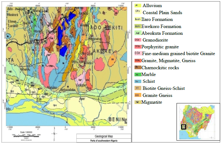
There have been several magnitude earthquakes in Nigeria since 1933. However, their exact causes are yet unascertained. This study focuses on delineation of underground geologic frameworks and hydrothermal alteration zones that could encourage seismic energy transmission, groundwater storage and mineralization within parts of Southwestern Nigeria. Data optimization was conducted using vertical derivatives, horizontal derivative, upward continuation, and analytic signal approach. The study area is dissected by sinistral and dextral faults along NE-SW, NW-SE, N-S, E-W directions. The NE-SW trend is typical of major lithospheric processes and fracture lines cross-cutting formation(s) underlying Ikogosi warm spring, Ipole-Iloro waterfall, Arinta waterfall and Effon-Alaaye waterfall (all in Ekiti state), and Erin-Ijesha waterfall (Osun State) which also dominated the current position of granite and adjoining fractures. The quartzite belt stretching in NE–SW direction is an aquifer network with significant storage potential. The NNE-SSW trends is typical of major lithospheric processes and fracture lines cross-cutting formation(s) underlying Ikogosi warm spring, Ipole-Iloro waterfall, Arinta waterfall and Effon-Alaaye waterfall (all in Ekiti state), and Erin-Ijesha waterfall (Osun State) which also dominated the current position of granite and adjoining fractures. The quartzite belt stretching in NE–SW direction is an aquifer network with significant storage potential. The NNE-SSW trends relates to Ifewara-Kalangai fault while NW-SE depicts the separation of South American from African plate. The overlap between NW-SE and NE-SW lineaments suggest fractures produced by similar tectonic events, probably the Pan African orogeny. Also, locations of lineament intersection are plausible zones for groundwater, geothermal and hosts to mineralized targets as evidenced by small scale mining activities in the area. These fault lines serve as channels for the transmission of seismic energy that gives rise to earth tremors. The mapped lineaments serve as guide in solid mineral prospecting and geothermal exploration. Results from this study has enriched existing knowledge about future earthquake occurrence which will assist in hazard prevention.

Dimensions

D. Vere-Jones, ‘‘Forecasting earthquakes and earthquake risk’’, International Journal of Forecasting 11 (1995) 503. https://doi.org/10.1016/ 0169-2070(95)00621-4.

Y. Y. Kagan and D. D. Jackson, ‘‘Long-term probabilistic forecasting of earthquakes’’, Journal of Geophysical Research: Solid Earth 99 (1994) 13685. https://doi.org/10.1029/94JB00500

Y. Ogata, ‘‘Statistical models for earthquake occurrences and residual analysis for point processes’’, Journal of the American Statistical Association 83 (1988) 9. https://doi.org/10.2307/2288914

Y. Y. Kagan and L. Knopoff, ‘‘Statistical short-term earthquake prediction’’, Science 236 (1987) 1563. https://doi.org/10.1126/science.236.4808. 1563

S. T. Mohammed, U. A. Lar, T. A. Yakubu, D. Dauda & A. K. Umar, ‘‘The Review of the historical and recent seismic activity in Nigeria’’, Journal of Applied Geology and Geophysics 3 (2015) 48. https://doi.org/10.9790/ 0990-03114856

K. U. Afegbua, T. A. Yakubu, O. U. Akpan, D. Duncan & E. S. Usifoh, ‘‘Towards an integrated seismic hazard monitoring in Nigeria using geophysical and geodectic techniques’’, International Journal of the Physical Sciences 6 (2011) 6385. https://doi.org/10.5897/IJPS10.375

A. Adepelumi, B. D. Ako, T. Ajayi, A. Olorunfemi, M. Awoyemi & D.

Falebita, ‘‘Integrated geophysical mapping of the Ifewara transcurrent fault system, Nigeria’’, Journal of African Earth Sciences 52 (2008) 161. https: //doi.org/10.1016/j.jafrearsci.2008.07.002

O. David, O. Aurelius Ojaina, K. Umar Afegbua & I. Kelvin Uche, ‘‘Geophysical evaluation of central Nigeria Earth tremor activities using high resolution airborne magnetic data’’, Advances in Research 23 (2022) 23. https://doi.org/10.9734/air/2022/v23i230327

D. E. Ajakaiye, M. A. Daniyan, S. B. Ojo & K. M. Onuoha, ‘‘The July 28, 1984 southwestern Nigeria earthquake and its implications for the understanding of the tectonic structure of Nigeria’’, Journal of Geodynamics 7 (1987) 205. https://doi.org/10.1016/0264-3707(87)90005-6

O. U. Akpan and T. A. Yakubu, ‘‘A review of earthquake occurrences and observations in Nigeria’’, Earthquake Science 23 (2010) 289. https://doi. org/10.1007/s11589-010-0725-7

O. M. Orji & H. O. Nwankwoala, ‘‘An overview of earthquakes and tremors in Nigeria: Occurrences, Distributions and Implications for Monitoring’’, International Journal of Geology and Earth Sciences 4 (2018) 56. https://doi.org/10.32937/IJGES.4.4.2018.56-76

A. Y. B. Anifowose et al., ‘‘Systematic multi-technique mapping of the Southern flank of Iwaraje fault, Nigeria’’, Journal of Applied Science and Technology 15 (2010) 70. https://doi.org/10.32937/IJGES.4.4.2018.56-76

S. I. Abaa, ‘‘The structure and petrography of alkaline rocks of the Mada younger granite complex, Nigeria’’, Journal of African Earth Sciences 3 (1983) 107. https://doi.org/10.1016/0899-5362(85)90029-6

A. I. Olayinka, ‘‘Geophysical siting of boreholes in crystalline basement areas of Africa’’, Journal of African Earth Sciences (and the Middle East) 14 (1992) 197. https://doi.org/10.1016/0899-5362(92)90097-V

P. Alken et al., ‘‘International geomagnetic reference Field: the thirteenth generation’’, Earth, Planets and Space 73 (2021) 49. https://doi.org/10.1186/s40623-020-01288-x

M. N. Nabighian et al., ‘‘The historical development of the magnetic method in exploration’’, Geophysics 70 (2005) 33. https://doi.org/10.1186/s40623-020-01288-x

J. B. Thurston, R. S. Smith,& J.-C. Guillon, ‘‘A multimodel method for depth estimation from magnetic data’’, Geophysics 67 (2002) 555. https://doi.org/10.1190/1.1468616

D. T. Thompson, ‘‘EULDPH: A new technique for making computer assisted depth estimates from magnetic data’’, Geophysics 47 (1982) 1. https://doi.org/10.1190/1.1441278

W. R. Roest, J. Verhoef & M. Pilkington, ‘‘Magnetic interpretation using the 3-D analytic signal’’, Geophysics 57 (1992) 116. http://dx.doi.org/10.1190/1.1443174

C. V. Reeves, ‘‘The Kalahari desert, Central Southern Africa: a case history of regional gravity and magnetic exploration in the utility of gravity and magnetic surveys’’, Society of Exploration Geophysics (SEG) 20 (1982) 209. https://doi.org/10.1016/0016-7142(82)90022-9

C. Reeves ‘‘Aeromagnetic Surveys: Principles, Practice & interpretation’’, Published by Geosoft (2005) 155.

I. N. MacLeod, K. Jones, and T. F. Dai, ‘‘3-D analytic signal in the interpretation of total magnetic field data at low magnetic latitudes’’, Exploration Geophysics 24 (1993) 679. https://doi.org/10.1071/EG993679

W. M. Telford, L. P. Geldart and R. E. Sheriff, ``Applied Geophysics, 2nd Edition.'', Cambridge University Press, Cambridge, UK., pp. 353-358, 1990. https://kobita1234.files.wordpress.com/2016/12/telford-geldart-sheriff-applied-geophysics.pdf

R. O. Hansen, R. Louis and V. J. S. Grauch, ``Magnetic method in near surface geophysics'' In: Near Surface Geophysics, Society of Exploration Geophysics, D. K. Butler, Ed. Tulsa Oklahoma, U. S. A, 2005, pp. 151 – 175. https://doi.org/10.1190/1.9781560801719.ch6

E. P. Loehnert, ``Major chemical and isotope variations in surface and subsurface waters of West Africa'', Journal of African Earth Sciences (and the Middle East) 7 (1988) 579. https://doi.org/10.1016/0899-5362(88)90047-4

M. Rajaram, S. P. Anand, K. Hemant and M. E. Purucker, ``Curie isotherm map of Indian subcontinent from satellite and aeromagnetic data'', Earth and Planetary Science Letters 281 (2009) 147. https://doi.org/10.1016/j.epsl.2009.02.013

Published

2024-01-20

How to Cite

Lithological and structural mapping of parts of southwestern Nigeria using aeromagnetic data. (2024). Recent Advances in Natural Sciences, 2(1), 54. https://doi.org/10.61298/rans.2024.2.1.54

How to Cite

Lithological and structural mapping of parts of southwestern Nigeria using aeromagnetic data. (2024). Recent Advances in Natural Sciences, 2(1), 54. https://doi.org/10.61298/rans.2024.2.1.54